Field Mobility & Agriculture (HADP)
Offline-First Mobile App, GIS Plot Boundary Mapping & Grower Operations
Enterprise field mobility application engineered for the Holistic Agriculture Development Programme (HADP). Built with React Native and an offline-first local SQLite database, the app empowers rural agricultural field officers to manage 3,440+ registered farmers, map multi-point GPS plot boundaries, record voice observations, capture geo-tagged inspection photos, log soil chemical NPK/pH analyses, and orchestrate farm activities without internet connectivity. Features an automated background sync engine that safely buffers local mutations and synchronizes bidirectionally with Frappe / PostgreSQL cloud backends via exponential backoff retries.
Interface Evidence & Workflows
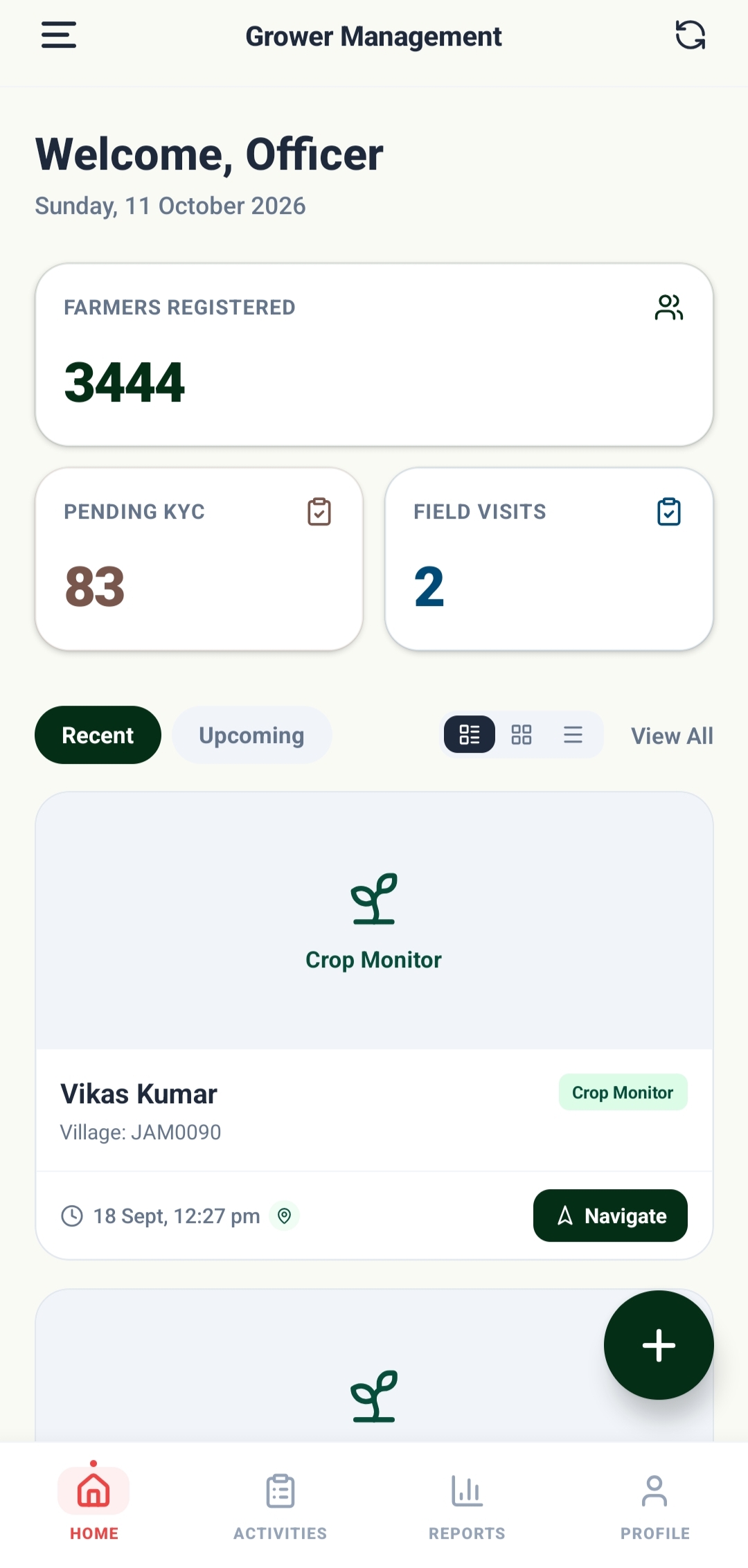
Officer Command Center & Real-Time Sync
Mobile field officer dashboard displaying 3,444+ registered farmers, KYC verification pipeline, scheduled field visits, crop monitoring alerts, and real-time offline sync status.
End-to-End Field Mobility & Offline Audit Lifecycle
Farmer Registration & Onboarding
Officers register farmers directly in the field, recording Aadhaar verification, farmer category, village affiliation, and landholdings with 100% offline local SQLite caching.
GPS Plot Boundary & Land Acreage Survey
Officers survey agricultural plots on-site by walking perimeters and placing multi-point GPS pins, dynamically computing calculated acreage (e.g. 11.47 Acres) and polygon geometries.
Daily Field Visit & Voice Audio Observations
Conduct routine crop inspections, record voice audio notes for fast hands-free documentation, log pest activity, and link observations to specific survey plots.
Geo-Tagged Photographic Evidence Capture
Capture field verification photos with immutable latitude, longitude, and timestamps watermarked directly into metadata to guarantee audit authenticity.
Soil Sample Collection & Chemical Lab Analysis
Collect farm soil samples, log standard NPK and pH lab metrics, analyze key chemical parameters, and issue instant pass or deviation status reports.
Self-Healing Offline-to-Cloud Synchronization
All offline records queue locally in SQLite. Once internet connectivity is restored, the sync worker executes batch transmissions with exponential backoff to Frappe cloud PostgreSQL.
System Layers & Technical Design
React Native (Expo) mobile application featuring offline SQLite database storage, dynamic GIS polygon boundary surveyor, camera geotagging engine, audio recording for voice visit notes, and NetInfo connectivity listeners.
Self-healing background sync queue engine with exponential backoff retries, conflict resolution handlers, Python REST API controllers in Frappe, and fuzzy matching algorithms for farm plot name resolution.
Device-level SQLite relational tables (Growers, Plots, GPS Coordinates, Field Visits, Soil Tests, Sync Queue) bidirectionally synchronized with cloud Frappe PostgreSQL.
The Engineering Challenge & Solution
Agricultural extension officers conduct inspections across remote rural villages with persistent cellular dead zones. Traditional cloud-dependent mobile apps suffered from catastrophic data loss during plot audits, inability to map irregular farm boundaries, duplicate grower registrations, and unverified paper claims. Furthermore, typing extensive inspection reports under harsh outdoor sunlight was impractical.
Architected an offline-first mobile application using local SQLite as the definitive client database. Built a GIS boundary mapping tool allowing officers to walk perimeters and drop GPS pins, integrated camera photo geotagging (stamping coordinates directly onto inspection images), added voice audio note dictation, and engineered an asynchronous background sync engine with exponential backoff and conflict resolution to push queued mutations to Frappe PostgreSQL once internet is detected.
Production Impact & Delivered Capabilities
Empowered officers to register, audit, and manage 3,444+ farmers and landholdings completely offline
Engineered multi-point GPS plot boundary mapping calculating acreage in real time (e.g. 11.47 Acres across 7 pins)
Implemented tamper-proof camera capture stamping immutable lat/long coordinates onto field inspection photos
Built hands-free voice audio note recording alongside structured visit notes for rapid field observations
Deployed standardized soil analysis testing module tracking NPK, pH, and 4 chemical parameters with instant pass/fail audit
Architected resilient SQLite self-healing sync engine with exponential backoff, eliminating dropped submissions
Architecture & Process Flow Models
Offline-First Sync & Field Mobility Architecture
Architecture diagram illustrating offline SQLite data persistence, background sync queue worker, network availability monitor, Python REST endpoints, and cloud PostgreSQL synchronization.